بحيرة مارتشيكا
تعد بحيرة مارتشيكا جد أهمية من الناحية البيئية و الطبيعية لإستظافتها العديد من لأنواع من الطيور المهاجرة وتعرف أيضا طحالب واعشاب بحرية نادرة وأيضا الإقتصادية لتشغيلعا حوالي 3 الاف صياد تقليدي موزعين حول مدينة الناظور وبني انصار وقرية أركمان في إقليم الناظور بالريف . مساحة بحيرة مارتشيكا 120 كم مربع ، عمقها بين 0.5 إلى 7 أمتار ، طولها 24 كم. بينها و بين البحر الأبيض المتوسط توجد شبه جزيرة بوقانا، نفس الإسم للممر البحري لها إلى البحر الأبيض المتوسط.
http://i216.photobucket.com/albums/cc280/rifspirit/marchica/nador-mar_chica1_800x600.jpg
http://i216.photobucket.com/albums/cc280/rifspirit/marchica/gorogo-marchica.jpg
http://i216.photobucket.com/albums/cc280/rifspirit/marchica/marchica.jpg
http://i216.photobucket.com/albums/cc280/rifspirit/marchica/La-Mar-Chica.jpg
http://i216.photobucket.com/albums/cc280/rifspirit/marchica/atalayun-vanaf-gurugu.jpg
http://i216.photobucket.com/albums/cc280/rifspirit/marchica/marchica39.jpg
http://i216.photobucket.com/albums/cc280/rifspirit/marchica/ATALAYOUN-PALEIS.jpg
http://i216.photobucket.com/albums/cc280/rifspirit/marchica/marchica29.jpg
http://i216.photobucket.com/albums/cc280/rifspirit/marchica/marchica36.jpg
http://i216.photobucket.com/albums/cc280/rifspirit/marchica/marchica20.jpg
http://i216.photobucket.com/albums/cc280/rifspirit/marchica/boukana-marchica.jpg
فرخانة
http://i216.photobucket.com/albums/cc280/rifspirit/farkhana/nadorcommunes-commune-Farkhana.jpg
بلدة فرخانة
http://i216.photobucket.com/albums/cc280/rifspirit/farkhana/farkhana.jpg
السوق المحلي
http://i216.photobucket.com/albums/cc280/rifspirit/farkhana/souk-farkhana.jpg
إيدوغوثن ساحل ” كالا طريفا”
http://i216.photobucket.com/albums/cc280/rifspirit/farkhana/idoghothen-cala-trifa2–.jpg
http://i216.photobucket.com/albums/cc280/rifspirit/farkhana/calatrifa-cuevas.jpg
http://i216.photobucket.com/albums/cc280/rifspirit/farkhana/cala-trifa.jpg
بني شيكار
الجماعة القروية بني شيكار (مسقط رأس الكاتب العالمي محمد شكري)
http://i216.photobucket.com/albums/cc280/rifspirit/aitchikar/commune-bni-chiker.jpg
1 كالا بلانكا
http://i216.photobucket.com/albums/cc280/rifspirit/aitchikar/calablanca-2.jpg
http://i216.photobucket.com/albums/cc280/rifspirit/aitchikar/calablanca-3.jpg
http://i216.photobucket.com/albums/cc280/rifspirit/aitchikar/calablanca-4.jpg
http://i216.photobucket.com/albums/cc280/rifspirit/aitchikar/calablanca-cueva.jpg
http://i216.photobucket.com/albums/cc280/rifspirit/aitchikar/ajelmam.jpg
http://i216.photobucket.com/albums/cc280/rifspirit/aitchikar/calablanca3.jpg
دنافيل
http://i216.photobucket.com/albums/cc280/rifspirit/aitchikar/dolfins.jpg
الطريق شمالا الى تيبوذا
http://i216.photobucket.com/albums/cc280/rifspirit/aitchikar/abrid-tresforcas-1.jpg
http://i216.photobucket.com/albums/cc280/rifspirit/aitchikar/abrid-tresforcas-2.jpg
2 تيبوذا
مينا روسيتا
http://i216.photobucket.com/albums/cc280/rifspirit/aitchikar/mina-rosita_tibouda.jpg
تيبوذا (بالأمازيغية تعني الحافات) وهو عبارة عن ميناء طبيعي الساكنة تعيش بالصيد التقليدي
http://i216.photobucket.com/albums/cc280/rifspirit/aitchikar/tibouda/Ifri-ndounecht.jpg
http://i216.photobucket.com/albums/cc280/rifspirit/aitchikar/tibouda/tresforcas5.jpg
http://i216.photobucket.com/albums/cc280/rifspirit/aitchikar/tibouda/tibouda.jpg
http://i216.photobucket.com/albums/cc280/rifspirit/aitchikar/tibouda/tibouda16.jpg
http://i216.photobucket.com/albums/cc280/rifspirit/aitchikar/tibouda/tibouda15.jpg
http://i216.photobucket.com/albums/cc280/rifspirit/aitchikar/tibouda/tibouda6.jpg
http://i216.photobucket.com/albums/cc280/rifspirit/aitchikar/tibouda/Tibouda3.jpg
3 رأس ورك (أو تريس فوركاس) وهو أقصى نقطة شمال إقليم الناظور
http://i216.photobucket.com/albums/cc280/rifspirit/aitchikar/tresforcas/tresforcas18.jpg
http://i216.photobucket.com/albums/cc280/rifspirit/aitchikar/tresforcas/tresforkas.jpg
http://i216.photobucket.com/albums/cc280/rifspirit/aitchikar/tresforcas/tresforcas4.jpg
http://i216.photobucket.com/albums/cc280/rifspirit/aitchikar/tresforcas/tresforcas-lighthouse3.jpg
http://i216.photobucket.com/albums/cc280/rifspirit/aitchikar/tresforcas/tresforcas27.jpg
http://i216.photobucket.com/albums/cc280/rifspirit/aitchikar/tresforcas/tresforcas3.jpg
http://i216.photobucket.com/albums/cc280/rifspirit/aitchikar/tresforcas/tresforkas8.jpg
http://i216.photobucket.com/albums/cc280/rifspirit/aitchikar/tresforcas/tresforkas6.jpg
http://i216.photobucket.com/albums/cc280/rifspirit/aitchikar/tresforcas/tresforkas4.jpg
http://i216.photobucket.com/albums/cc280/rifspirit/aitchikar/tresforcas/tresforkas2.jpg
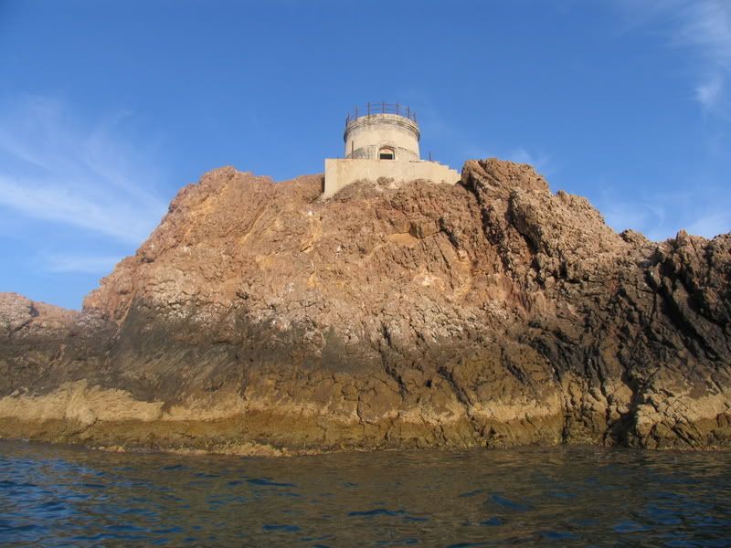
برج الفارايون وهو يوجد على صخرة أقصى شمال رأش ورك.

4 طرامونتانا
http://i216.photobucket.com/albums/cc280/rifspirit/aitchikar/tramontana-2.jpg
http://i216.photobucket.com/albums/cc280/rifspirit/aitchikar/tramontana-1.jpg
5 تشارانا
http://i216.photobucket.com/albums/cc280/rifspirit/aitchikar/tcharrana/charrana-1.jpg
http://i216.photobucket.com/albums/cc280/rifspirit/aitchikar/tcharrana/charrana-2.jpg
http://i216.photobucket.com/albums/cc280/rifspirit/aitchikar/tcharrana/charrana-3.jpg
http://i216.photobucket.com/albums/cc280/rifspirit/aitchikar/tcharrana/charrana-4.jpg
http://i216.photobucket.com/albums/cc280/rifspirit/aitchikar/tcharrana/charrana-5.jpg
http://i216.photobucket.com/albums/cc280/rifspirit/aitchikar/tcharrana/charrana-6.jpg
http://i216.photobucket.com/albums/cc280/rifspirit/aitchikar/tcharrana/charrana-7.jpg
http://i216.photobucket.com/albums/cc280/rifspirit/aitchikar/tcharrana/charrana-8.jpg
http://i216.photobucket.com/albums/cc280/rifspirit/aitchikar/tcharrana/charrana-9.jpg
http://i216.photobucket.com/albums/cc280/rifspirit/aitchikar/tcharrana/charrana-10.jpg
6 غساسة
نعلم من خلال البكري أن غساسة كانت تابعة لمملكة نكور. إذ من المبدئي احتمال وجود قلعة وميناء بشبه جزيرة ورك Tres forcas. خلال القرن الثاني عشر تحدث الإدريسي عن مرسى كرط في هذه المنطقة، الذي لا يمكن أن يكون سوى غساسة، خصوصا وأن هذا المؤرخ يشير إلى بعد غساسة عن مليلة باثني عشر ميلا، وعن مدينة المزمة الأثرية بعشرين ميلا، وهو ما يصادف كرط بتتبع الساحل. ويجهل معظم المؤرخين اللاحقين وجودها.
في القرن الرابع عشر يتحدث عنها ابن خلدون والعمري كمدينة، هذا الأخير يشير في “المسالك” إلى أنها كانت تسمى”الكدية البيضاء”. ويضيف العمري أن غساسة كانت تؤدي ضريبة تقدر بثلاثين ألف دينار، رقم مساو لما كانت تؤديه تازة، مليلة والمزمة، مما يدعنا نستنتج أن المدينة عرفت نموا كبيرا، وأنها كانت تعد بعد سبته إحدى أهم مدن الريف.
وبميناء غساسة نزل أبو عبد الله، آخر ملوك بني نصر، بعد مغادرته غرناطة إثر سقوطها سنة 1492. وبعد سنوات من سقوط مدينة مليلة، تحولت أنظار الإسبان إلى غساسة فتمكنوا من احتلالها سنة 1506، وتم تحريرها بعد ذلك من طرف المقاومة المتمركزة في تازوضة[6]. ولكنها خربت بعد ذلك نظرا لوجود التهديد المسيحي الإسباني الدائم، ولقلة مداخيل الميناء[7].
ورغم أنها كانت موضوع حفائر أركيولوجية أنجزها مؤرخ مليلية الرسيمي فرنانديث دي كاسترو خلال الأربعينيات توجت بنشر كتاب حول تاريخها، إلا أننا لا نتوفر على تصاميم واضحة لمعالم المدينة. كل ما تبقى هو جدار إحاطة مختلط تم بناؤه بالطابية ويبلغ طوله حوالي 200 متر وعرضه يتراوح بين 60م و140م[8].
http://i216.photobucket.com/albums/cc280/rifspirit/aitchikar/ghassassa/ghassassa-athar.jpg
شاطئ ثيسي نوانو (شاطئ غساسة) أين نزل آخر ملوك غرناطة بعد سقوطها
http://i216.photobucket.com/albums/cc280/rifspirit/aitchikar/ghassassa/ghassassa-2.jpg
غابة تارديت القريبة من شاطئ غساسة
http://i216.photobucket.com/albums/cc280/rifspirit/aitchikar/ghassassa/ghassassa-rghabeth-tajdirt.jpg
مقهى البستان في ثيزا (قرية قريبة من غساسة) هذه المقهى على الشكل نمط الريفيين قديما يزورها الكثير من الاسبان لخصوصيتها و هدوئها ففيها المقهى والمطعم والحديقة والمتحف كل هذا على شكل النمط المعيشي القديم.
http://i216.photobucket.com/albums/cc280/rifspirit/aitchikar/ghassassa/lboustan2.jpg
http://i216.photobucket.com/albums/cc280/rifspirit/aitchikar/ghassassa/lboustan3.jpg
http://i216.photobucket.com/albums/cc280/rifspirit/aitchikar/ghassassa/lboustan5.jpg
http://i216.photobucket.com/albums/cc280/rifspirit/aitchikar/ghassassa/lboustan4.jpg


مناظر رائعة ماشاء الله لاقوة إلا بالله